Home Multi-Country Search About Admin Login
Neogene
Paleogene
Cretaceous


Compiled by: Jacques LeBlanc (2021), Stratigraphic Lexicon: The Onshore Cenozoic Sedimentary Formations of The Republic of Panama. Biosis: Biological Systems, vol. 2/1, 1-173. https://doi.org/10.37819/biosis.002.01.0095(or via https://sites.google.com/site/leblancjacques).

Search by
Select Region(s) to search
Hold Ctrl (Windows/Linux) or Command (Mac) to select multiple
Aguadulce Gr

Aguadulce Gr


Period: 
Quaternary

Age Interval: 
Holocene to Recent - Instituto Geografico Nacional (IGN) "Tommy Guardia" (1996)


Province: 
Tonosí & Azuero basin

Type Locality and Naming

Hershey O.H. (1901) (Figure 1) defines it as a formation rather than a group (p. 258). “In this formation near Aguadulce are many small, smooth, subangular pieces of limonitic chert and hardened clay which have a peculiar semi-glazed surface and a uniform light brown color. A great number of these same water-worn brown pebbles are scattered over the plain far from the sea, particularly in the vicinity of the more important stream courses. They appear to be the river deposits of a certain age, as none were formed before or since.”

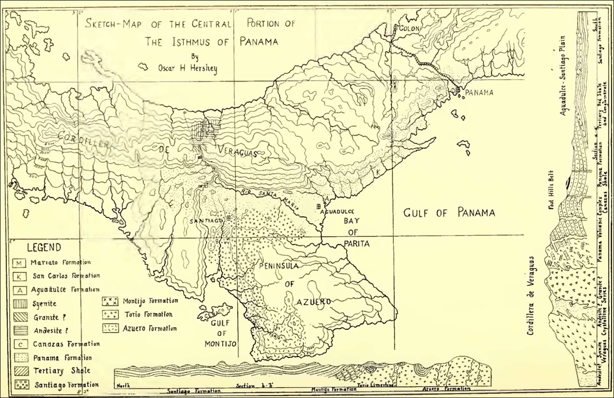
[Figure 1. The earliest known geological sketch map of the Central Portion of the Isthmus of Panama zoomimg in on the Azuero Peninsula. The map displays the formations known at that time and described by Hershey (1901).]

Synonym:


Lithology and Thickness

Ministerio de Comercio e Industrias (1991) uses the name as a Group and includes in it the (1) Las Lajas Fm (above), (2) Río Hato Fm (middle) and (3) Boca de Chucara Fm (below). These are described as:

alluvium, consolidated sediments, sandstones, corals, mangroves, conglomerates, carbonaceous shales, deltaic type depositions

Conglomerate, sandstones, shales, tuffs, semi-consolidated sandstones, pumice

Alluvium, sand, carbonaceous shales, organic deposits with pyrite, deltaic type.


Lithology Pattern: 
Clayey sandstone


Relationships and Distribution

Lower contact

N/A

Upper contact

N/A

Regional extent

Occurs in Aguadulce Plain, Coclé province


GeoJSON

null

Fossils


Age 


Age Span: 

    Beginning stage: 
Holocene

    Fraction up in beginning stage: 
0

    Beginning date (Ma): 
0.01

    Ending stage: 
Holocene

    Fraction up in the ending stage: 
1

    Ending date (Ma):  
0.00

Depositional setting


Depositional pattern:  


Additional Information

References:

  • Hershey O.H. (1901)
  • Woodring (1960) states “Poorly defined name for surficial deposits. Pleistocene(?)”
  • Keroher et al. (1966)
  • Ministerio de Comercio e Industrias (1991)Instituto Geografico Nacional (IGN) "Tommy Guardia" (1996)’s map keeps it as a Group and includes in it only the Las Lajas Fm (above) and Río Hato Fm (below) in it. There is no mention of the Boca de Chucara Fm and the reason why it was removed from the Group.


Compiler:  

Jacques LeBlanc (2021), Stratigraphic Lexicon: The Onshore Cenozoic Sedimentary Formations of The Republic of Panama. Biosis: Biological Systems, 2(1), 173 pp. https://doi.org/10.37819/biosis.002.01.0095 (or via https://sites.google.com/site/leblancjacques)